Traversing The Canol Road - A BikeRafting Adventure Across A Failed Alaskan Pipeline
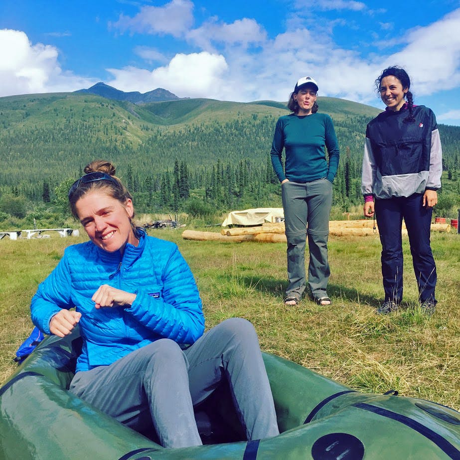
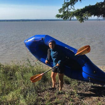
Though it was supposed to cost just million, the Canol Road and Pipeline went million over budget in the early 1940s and turned out to be a monumental failure. Five ladies, Sinead Earley, Hannah Johnston, Rohanna Gibson, Caitlin DuBiel, and Gabriela Stephens, decided to traverse this road via bike and packraft summer of 2017. We loaned them packrafts for their adventure.
Photos and text by Hannah Johnston
During the second world war the United States government decided to develop inland transport infrastructure to service Alaska. Fearful of attacks from Japan, coastal shipping channels were thought to be too vulnerable, and so, with the blessing of Canada, the United States government poured millions into three large construction projects in the north. The first was a series of small landing strips throughout the Alaska, the Yukon and Northwest Territories to support air transport; the second was the Alaskan Highway; and the third was the short-lived and lesser-known Canol Pipeline (and an access road to service it), which was built to meet Alaska’s energy needs with a northern source of Canadian crude.
The Canol was, by most accounts, a complete disaster. The pipeline was built from Norman Wells, Northwest Territories, to Whitehorse, Yukon. From Whitehorse, the plan had been to pump crude out to nearby Alaska. Originally bid at 34 million dollars, the project was ultimately over budget by a hundred million dollars and the surface pipeline lost over 15 percent of everything it transported. A mere two years after the Canol was completed, support for the project was pulled. Sections of the pipeline were auctioned off; valuable items were removed and everything else was left to be reclaimed by the wild. However, in the arctic – an part of the world with long winters and a dry climate – reclamation takes a long time…. and so, 70 years after the building of the Canol Pipeline and the Canol Road echoes of the road remain. I was part of a group of five women who decided to try and ride it.
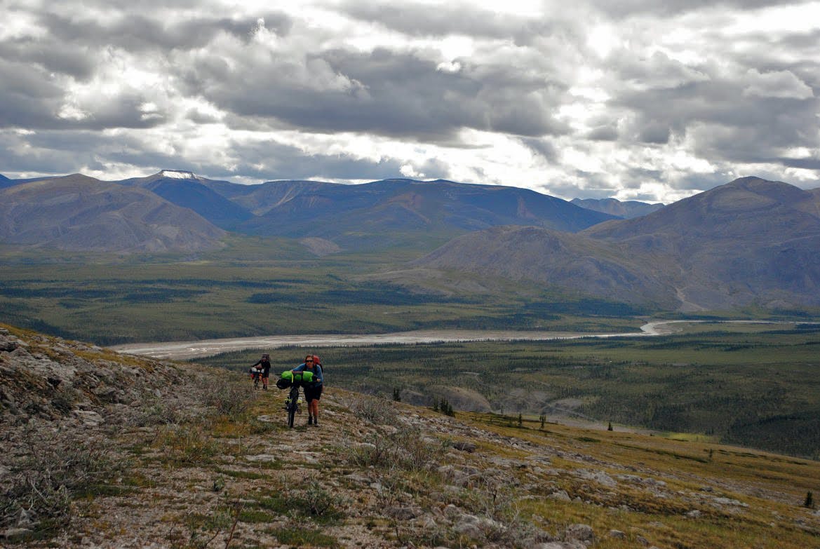
The Canol traverses the Mackenzie mountains, some of the most remote and rugged of what Canada has to offer. Bears, caribou, porcupines, fox, and birds abound. The landscape is rich with life and minerals, and history. Only a handful of people traverse the trail each year. Fewer yet have done it on bicycle.
At present, the Canol can be divided into four main sections. From the south they include: the south Canol, the North Canol on the Yukon side, the NWT border to the Twitya river, and the Twitya to the Mackenzie. Travelling north, each section is more rugged and wild than the one before it.
The South Canol
The South Canol Road begins at Johnsons Crossing where the pavement ends. This section of the road is 225 kilometers of dirt road. It is slow going, but passable by car. We decided to drive this section, and rented a truck and a trailer. Instead we determined that we would depart by bicycle from Ross River, Yukon. From Ross River, you cross the Pelly River on a cable ferry and then there is no turning back. No more towns, no more intersections, one way in and one way out.
Ross River to the NWT/Yukon Border
The Yukon Government maintains the North Canol Road. It is a beautiful gravel grind for about two hundred and fifty kilometers. Travelling alongside the Pelly River the road rises and falls until you begin the long and slow climb toward the Mackenzie Mountains. Views of glaciers on Itsi mountain, valleys of wild flowers, mountains with iron coloured scree slides, and beautiful bridges that pass over rushing rivers and streams. It is a section where you can cover ground quickly if you pack lightly and your legs are feeling strong. It is a section where you might pass a road crew, or a hunting guides returning at the end of their season, but people are few and far between. Our weather was amazing and the further we rode into the mountains the more beautiful the landscape became.
Yukon/NWT border to the Twitya
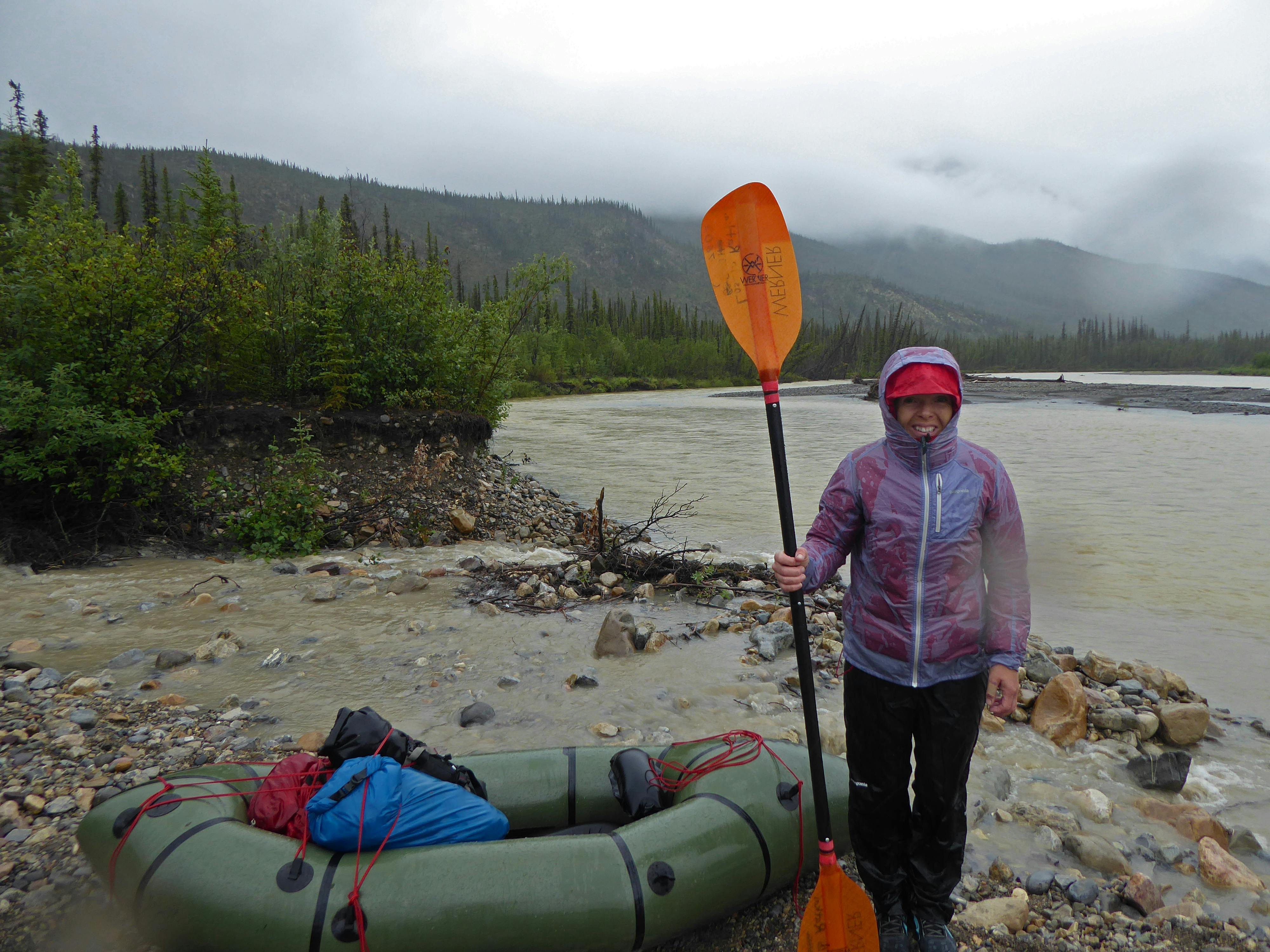
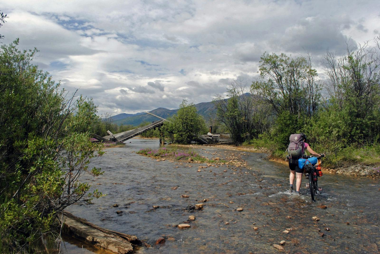
Road maintenance stops at the NWT border. When we had considered what it might be like to ride on a road with no maintenance, we expected that the bridges would be out, that the road would be marked with potholes, and that there would be runoff from years of rains. It hadn’t dawned on me that every would-have-been culvert would instead be a small stream- and that these streams would equate to wet feet, pristine beaver habitat, and in times of hard rains or quick snowmelts would produce a ruthless rush of water that would reclaim the road we sought to follow.
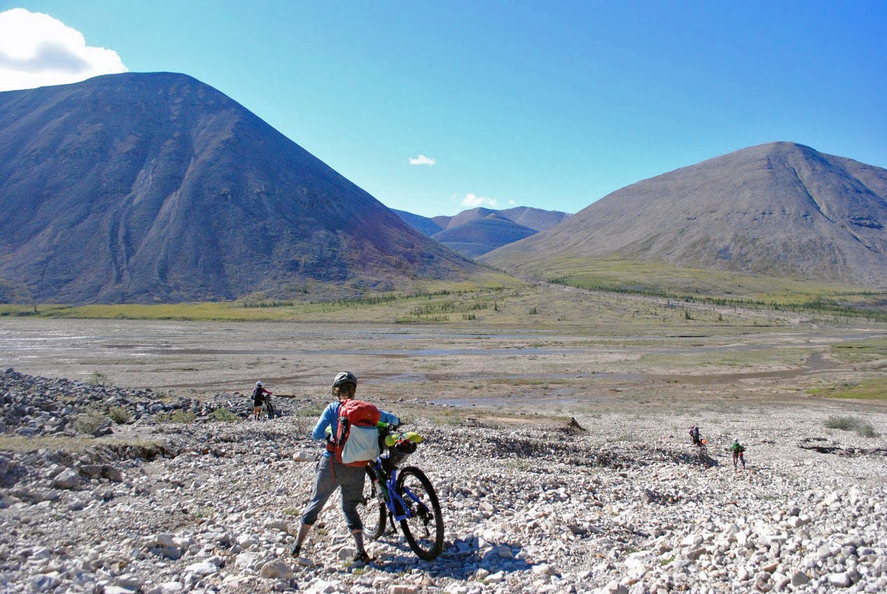
The road straddles something between washed out jeep tracks and, alpine meadow, river bed, or overgrown forest with a path that hints at single track. Along the road you will find piles of oil drums, abandoned trucks, and old pump houses. The mountains become bigger and more beautiful, the passes long, and the descents loose.
Every once in a while an ATV enthusiast will drive as far as the border, unload their off-road machines, and drive as far as they can up the Canol Road. Then they hit a river, too wide, deep, or swift to continue; they turn back and drive the same road out to Ross River. We knew that pack rafts were key to making the trip and had arranged for them to be dropped just on the NWT side at Dechenla, a naturalist lodge located near an old landing strip. This would save us the weight on the ride in.
After seven crossings of the Ekwi river, we arrived at Godlin Lake, an old fly-in hunting camp run by Canol Outfitters. By the time we reached the camp, we had been nursing along a bicycle with an irreparable mechanical issue. Glenda, who runs the outfit, managed to help us arrange for a wheel to be sent up with her next group of incoming hunters. The mechanical put us behind schedule. The loss of time would ultimately cause us to fall short of our goal, but with the help of Glenda and her team, we all managed to make it back out on the trail.
The Twitya to the Mackenzie
For the ATVers making a run at the Canol, the Twitya River is the end of the line. With five riders and three rafts and so many river crossings, we would save the rafts to shuttle riders and gear across the widest and deepest crossings. When our crew reached the bank of the Twitya, it was after two days of rain. The river was swollen and fast. Bodies were cold, morale was low, everything was wet. The conditions were suboptimal, but we did it. After the Twitya, road conditions (if you can call it a road), deteriorated significantly.
At each washout, at every rock slide, and whenever the road disappeared into the river and we could make out its faint re-emergence some 200 meters downstream we wondered who would have ever put a stamp of approval on such a crazy undertaking. In the search of the flattest possible route, the road was built up stream beds full of boulders the size of lawnmowers. It was as if the Canol predated not only civil engineering, but any understanding of fluid dynamics. The deterioration was so extreme that we had to rely on the most recent maps (from the late 1970s/early 1980s) and GPS coordinates just to estimate our way.
By this point our bikes were more of a hindrance than a help. Maybe 50% was rideable. The challenge was both physical and mental. Pushing bikes up washed out river beds and hoisting over rocks and streams was trying. The power of water and ice to make and remake landscapes is vast; it is hard to comprehend how a surface pipeline through such a rugged landscape would have ever been considered a feasible project.
Again and again we returned to thoughts of the people who built the road, imagining how much more difficult their living and labour conditions were than what we had the privilege of experiencing. We also wondered often of the telegraph crew who was working on trail remediation, to remove telegraph wires that for years had entrapped the antlers of caribou in search of food on their annual migration. Their occasional bag of wire, left for future pickup, or small shrub cut with a hand saw, helped to guide our way.
We continued for a few days more… across Andy creek, up and over the plains of Abraham, and down to the Keele. With three days until our flights out of Norman Wells, we had significant distance to cover and what was left of the road, paired with maps from the 1980s tested our wayfinding abilities. We travelled all night, but when the road divided we found the overgrowth was impassable. We came to the painful realization that we would come up short of our goal to finish the Canol.
We turned on the InReach and messaged our helicopter contacts. Not 20 minutes later we heard the hum of helicopter blades. I reread my message hoping that it hadn’t been interpreted as an SOS. The helicopter flew over and circled back around and landed. It wasn’t the lift we were waiting for, but a chance meeting.
Out jumped four members of the telegraph wire crew. Word had spread we were headed their way and they dropped in to see how we were doing. The meeting was a powerful one. It gave us an opportunity to express our gratitude for their work, to discuss how beautiful and magical the mountains were, and to hear about the parts of the trail we wouldn’t see. The conversation also provided us with closure to our trip even though we fell short of our goal. We continue to follow their remediation work with much admiration.
Many thanks to Porcelain Rocket, Mountain Laurel Designs, Alpacka Rafts, Altra Shoes, Oiselle, OnSight, and Juliana Bikes for material support; Krave Jerky, Hammer Nutrition, Epic Bars, Wilder, Tanka, and Macro Bars, Justin’s Nut Butters, and Vermont Meat for keeping us fed; endless support and wrenching assistance from our respective local bike shops (Chucky, Garrisons, Bloomfield, Cycle Logic); and funding from the University of Northern British Columbia and The Puffin Foundation to support our forthcoming documentary.
To read ‘daily journal’ entries check out our Conol Doc website. For photos of the trip find us on Instagram @canoldocproject; individual riders also posting pictures from the Canol trail and other adventures @gabistephens; @twowheelsnorth; @searliness